|
More than a year has passed since the last Design of a Variant
article was published here. Readers unfamiliar with the content
of the first or second
articles may wish to read them before
continuing. As with the previous articles, I am writing now
to document the process of variant development so that people
might more easily develop variants themselves. There have been
several important developments concerning Maharajah's Diplomacy,
the most important being that I have overhauled the map, based upon
comments received, and the outcomes of some playtest games, resulting
in the release of version 2.0 of the variant. Updating the code on
the USTV judge has also been completed (though at this the time of
this writing, the accompanying "floc.net" still awaits completion),
and Maharajah's Diplomacy has been added to the Realpolitik
adjudication program. A download of the Realpolitik files
for the variant may be obtained, among other places,
at the variant home page.
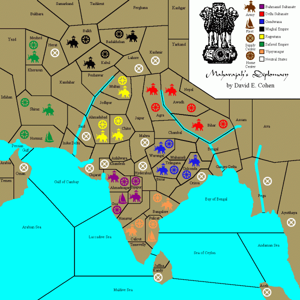
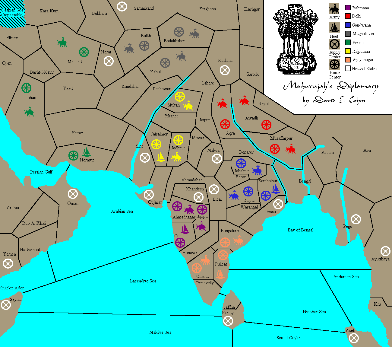
Regarding the map, I had kept an open mind as to possible changes. The most frequent comment I received from players and observers of the playtests concerned congestion in parts of the subcontinent, which led to a certain feeling of diplomatic inflexibility, that is, some players would not leave a fully defensive stance because they felt that the closeness of the various positions left them too vulnerable, or that any maneuvering at all might be construed as hostile by multiple neighbors, not all of whom were the intended target. Also brought up fairly often were the superiority of the edge positions, especially that of the Safavid Empire, and the inferiority of the positions of the central Powers, though just which Powers were central was subject to some debate. In addition, I received several comments concerning the limited usefulness of the navigable rivers, and of fleets in general. Finally, upon review of my research materials, I had noticed several instances where I had used province names that were either geographically or chronologically inaccurate, and I wanted to fix or at least minimize those errors. So, as the results and comments came in, I began tinkering. The former and current maps for the variant are reproduced here for ease of comparison.
The first thing I did was combine Indus Delta with Sind, and Ganges Delta with Bengal, both historically accurate changes, which had the added benefit of entering the large river valleys easier. I then looked once more at the possibility of enlarging the map. Going north would add no water of consequence, and did not seem to offer any other benefits. Expanding to the south would add water, but no land worth mentioning, so that didn't seem a productive avenue to explore either. Adding to the map on the east would add both land and water, but the water areas would be disconnected unless I also expanded the map to the south. Doing so would probably change the scale of the variant, which I wanted to keep close to that of Standard, and the new Supply Centers created would be located far from the center of the board, probably ending up as additional safe builds for only a few of the Powers, most likely Vijayanagar, which didn't really need the help, as it presently had the option of two different possible "safe" builds already. That left the option of expanding the map to the west. I could only do this by a small amount, or once again the scale would be off, but that small amount enabled me to include the tip of present day Somalia (Seylac, in the variant) which I made a Supply Center, and it also gave me the opportunity to enlarge the portion of the Arabian Peninsula covered by the map, while still maintaining it as separate from the main part of Asia. I decided that Yemen, which I could now separate from Oman by (three, as it turned out) buffer provinces, could also be given Supply Center status. With two Supply Centers and five provinces in total, the Arabian Peninsula would also offer some visual and play variety, since the geography would be different from the other offshore land areas, which were "lonely dots" (one or two province islands). Unlike the other offshore areas, an army might have real use there. The total number of Supply Center provinces now stood at 37, which appealed to me. Keeping the number of supply centers odd (and changing it from 35, in the previous version, to a prime number) should continue to discourage draws. By redrawing the western water provinces, Bahmana (formerly the Bahmanid Sultanate) could be given good access to these Supply Centers, beefing up the position considerably. With five offshore Supply Centers (Aceh, Kandy, Oman, Seylac and Yemen), the use and importance of fleets would increase. The additional land on the mainland portion of the map would also allow me to redraw the boundaries in and around Persia (formerly the Safavid Empire), which, if done correctly, would lessen its offensive and defensive capabilities, which were often perceived by commentators as being too strong. The expansion also put the southeastern portion of the Caspian Sea as a disconnected body of water in the northwest corner of the map. I considered connecting it to the main water areas, but could find no historically appropriate way to do this. No canal had ever connected the Caspian Sea to the Persian Gulf or the Arabian Sea, either directly, or linked by rivers. The longest river in the area, the Oxus (today, the Amu Darya), flowed west through the northernmost portions of the map to the Caspian Sea in 1501, the year in which Maharajah's Diplomacy begins (the course of the river has since changed; it now flows north, to the Aral Sea). But adding the Oxus River and Caspian Sea did not add to the play potential in that part of the map, so I decided to leave the Oxus off, and I made the Caspian Sea impassable. The outer boundaries of the revised map were now set. The tasks I now set for myself were to make good use of the map area, by increasing the ability of players to maneuver, and by increasing the usefulness of fleets, while simultaneously compensating for the natural positional advantages of the edge Powers. I will discuss the changes I made geographically, on a Power-by-Power basis rather than chronologically, both because of the numerous changes made and because, from time to time, I had multiple designs under consideration simultaneously. I will also use the province names from version 2.0 rather than from the previous version of the map, but as I have done previously in some instances here, I will note the old name parenthetically, where it differs, the first time a province is mentioned. I will begin the discussion with Persia, and go around the map in a roughly clockwise manner, so that the flow and relationship of the changes may be more easily followed. As previously stated, Persia was generally viewed as the strongest of the Powers in the first version of Maharajah's Diplomacy, with the Safavid players, Suzanne Castagne and Kwok-Sum Poon, each soloing in their respective games. While I did not think that the variant was especially unbalanced (in fact, the Safavid player was the first eliminated in both the third and fourth playtests), I was not averse to making Persia a bit weaker, especially if doing so got me closer to my other goals. In the redesign, I moved the Supply Center in Shiraz to Isfahan, added several buffer/flank provinces (from the north, Kara Kum, Elburz, Dasht-I-Kavir and Qom), and merged Khorasan into Yezd. Together, these changes reduced the offensive capability of Persia, because a player no longer had the option of an all-purpose offensive and defensive move to Kandahar (and Kandahar didn't front on Rajputana anyway, because I had extended Peshawar so that it bordered on Sind). Defensively, Persia was weakened as well, because of the increased isolation of the Supply Center in Meshed. Persian players would now need to commit earlier, or adopt a more defensive outlook. On the other hand, with the addition of a second coastal home Supply Center, and the additional offshore neutrals, a predominantly naval strategy was now a more realistic option for Persia, and the increased separation of Persia from its neighbors would tend to make a long term alliance with Persia easier to form. If Persia forgoes an immediate attack on its neighbors, Bahmana, Mughalistan (formerly the Mughal Empire) and Rajputana, and is not attacked itself, it has a reasonable chance of obtaining multiple first-year builds. Depending on specific, in-game negotiations, Oman, Herat, Sind and Gujarat are all possible conquests. Persia may also be in contention to take Yemen in 1502, since (due to the configuration of the map) Yemen will be one of two neutral Supply Centers vacant at the end of 1501. My concern with Mughalistan was primarily one of getting more separation from its neighbors, so that it could expand in one direction without appearing to be a looming threat to everyone else. I had already accomplished this with Persia, but the more serious problem lay in the east, with Delhi (formerly the Delhi Sultanate) and Rajputana. After some more thought, I decided that the best way to do this would be to get rid of the Supply Center in Lahore. Kashmir would still be a source of conflict between Mughalistan and Delhi, but the problem of early, long-term tactical gridlock due to the mass of closely packed dots in the area would be alleviated. But I couldn't just remove the supply center. Mughalistan could very easily be held out of its most likely neutral targets, Kashmir and Herat, and have no builds in the first year, unless a successful first year attack was mounted on Delhi, Persia or Rajputana. I therefore placed a Supply Center in the north, in Samarkand, which I had combined with Tashkent. Now Mughalistan had a "sure" build, but moving there from Balkh or Badakhshan, since I had shifted the border of Ferghana to allow for access by either Mughal army, would mean a decreased chance of taking another neutral, so this advantage did not come without a price. Finally, to give Mughalistan more of the reason to care about what was happening in the ocean, in addition to having Peshawar border on Sind, I extended the Indus River a bit further to the northeast, and gave Kabul river frontage. Delhi, along with increased separation from Mughalistan due to the removal of the Supply Center from Lahore, has a new buffer province, Mewar, increasing the breathing room between Delhi and Rajputana. Further south, however, the buffer province of Mahanadi has been removed, so relations between Delhi and Gondwana may be a bit tenser, though both could still easily ally or go their separate ways, since a band of buffer provinces remains between them. The more significant changes for Delhi lie in the southeast, where the border I created between Ava and Muzzafarpur (formerly Bihar) will enable Delhi to try for either Pegu or Ayutthaya, instead of Ayutthaya only being a possible first year conquest for Vijayanagar. Other possible neutral conquests for Delhi in 1501 include Malwa, or Orissa, and of course, Delhi can mount direct attacks on Gondwana, Mughalistan or Rajputana. Finally, the previously mentioned combination of Ganges Delta with Bengal should make strategies featuring a significant naval component more viable. Gondwana underwent several significant changes. In addition to gaining a river frontage, all of the Gondwanan home provinces and several of the neighboring spaces were renamed and reconfigured. I added the river frontage after noting on my reference maps that an arm of the Ganges River, the Hooghly, flowed south to the Bay of Bengal considerably west of the main river delta. Since many of the likely initial moves for a unit in the newly created province of Sambalpur would be to other river provinces, I decided to start Gondwana with a fleet in Sambalpur. My thought was to add some tactical variety to that area of the board. In the prior version of Maharajah's Diplomacy, Vijayanagaran command of the eastern water provinces often went unchallenged for most of the game. I also moved one of the Gondwanan starting armies away from Bidar (formerly Hyderabad). Gondwana, Bahmana and Vijayanagar would now each initially have one army next to Bidar (Rajpur, in the case of Gondwana), which would make for some very interesting negotiations. Similarly, the army in Jabalpur, Gondwana's third starting unit, would be two moves away from the neutral Supply Center in Malwa, as are armies from Bahmana, Delhi, Rajputana and Vijayanagar, so any Power attempting to take Malwa must be prepared for intense negotiations. Unlike some of the other Powers, Gondwana has no "automatic builds" in 1501. It does, however, have an excellent chance to obtain multiple builds from a group of Supply Centers including Bidar, Malwa, Orissa and Pegu, and of course, a Gondwanan player can mount first year attacks on Bahmana, Delhi, Rajputana or Vijayanagar. I believe that the strength of Gondwana lies in its great flexibility. Gondwana can make an excellent ally for any of its neighbors, and with purposeful negotiation, it is well situated for further expansion. Each of the Gondwanan starting units has several potentially effective moves, arguably giving Gondwana a more flexible initial position than any of the other Powers. In contrast, I left the Vijayanagaran initial home Supply Centers unchanged, but I did alter some of the nearby provinces. I split the province of Kra off from Ayutthaya, and split off the eastern part of Maldive Sea (which was connected to Seylac), renaming it Sea of Ceylon (the old sea of Ceylon was renamed Nicobar Sea). These changes gave the Powers in the area more maneuvering room. Vijayanagar no longer has a choice of "automatic" neutrals for its fleet, and the improved access to water for Delhi and Gondwana makes the Vijayanagaran position less secure, since it can no longer send its fleets west while being unconcerned about foreign naval units in the east. The neighboring Powers may contest control by Vijayanagar of any of the nearby neutral Supply Centers except Aceh, those being Ayutthaya, Bidar, Kandy, Orissa and Pegu. That said, Vijayanagar still has a good defensive position, and with the addition of new "offshore" neutral Supply Centers, Vijayanagar's excellent access to water could form a good basis for further expansion, if an immediate or delayed attack on Bahmana or Gondwana is not considered advantageous. My main concern with Bahmana was giving it some additional separation from its neighbors, accomplished by several previously mentioned changes, and by the extension of the province of Ahmadabad (formerly Anhilwara) to the Arabian Sea. While this cuts Bahmana off from immediate access to Gujarat, this is compensated for by the addition of Seylac, to which only Bahmana has first year access. Bahmana also has the sole immediate access to Khandesh, as well as a chance to take a number of other neutral Supply Centers, including Kandy, Malwa and Oman, and first year attacks on Gondwana, Persia, Rajputana or Vijayanagar can be mounted. Bahmana, then, has excellent first year, which provide compensation for its less than secure central starting position. With ready access to the dot-rich center of the board, and frontage on the Arabian and Laccadive Seas, Bahmana has a flexible position with excellent opportunities for growth. Depending on the ally, Bahmana can move strongly with armies, or adopt a primarily naval orientation. Greater separation from Bahmana, Delhi, Mughalistan and Persia has also benefited the position of Rajputana. With the movement of the Persian Supply Center of Shiraz to Isfahan, Persia must forego Oman to contest an immediate occupation of Sind by the Rajputanan fleet (changed from an army) in Jaisalmer (formerly Ahmadabad). Further, the army in Jodhpur (formerly Chitor) cannot be opposed if an immediate move is made to Gujarat. Though the province of Peshawar has been extended south to Sind, a Spring 1501 move there by Mughalistan is not overly likely, since Army Kabul will often be need elsewhere. Still, Rajputana has a remedy to that in its third unit, Army Multan. The unit has a large variety of possible uses. A defensively minded Rajputanan could move to Bikaner (formerly Jodhpur), covering all the Rajputanan home Supply Centers, while players more inclined toward offense have possible moves to Jaipur, Lahore or Peshawar to consider. Depending on whether the Rajputanan player wishes to make certain neighbors nervous or angry, or upon how successful Rajputanan diplomacy has been, neutral dots could also be gained in 1501 in Bidar, Kashmir, Khandesh or Malwa, or immediate attacks can be attempted on Bahmana, Delhi, Mughalistan or Persia. I will now move on to a discussion of the map as a whole. With 37 Supply centers out of a total of 77 provinces (48.05%), Maharajah's Diplomacy is slightly bigger and more densely "dotted" than Standard Diplomacy, which has 34 Supply Centers out of a total of 75 provinces (45.33%). By itself, this increased density would tend to make stalemates slightly more likely to occur in Maharajah's Diplomacy. David Norman has pointed out some "majority" stalemate lines (stalemate lines where two or more Powers can hold a majority of the Supply Centers on the board indefinitely against another Power or Powers). I am aware of others, and though no comprehensive analysis has been made, my present belief is that such majority lines will prove to be slightly less common in Maharajah's Diplomacy than in Standard. Where the particular configuration of the board and the specific variant rules have a big influence is in making "minority" stalemate lines (where a Power or Powers holding less than half of the Supply Centers on the map may hold off the other Powers on the board indefinitely) much less common, despite the slightly higher map density. With the ability of the Powers to gain new home Supply Centers, the inability to build anywhere on the board, one of the major aids to creating stalemates in Standard Diplomacy, is no longer a factor. Not having an impassable province in the middle of the map, dividing possible avenues of attack, also makes stalemate lines more difficult to form. Paul Stuckwisch (with some help from me) has performed a fairly extensive analysis of possible minority stalemate positions. I will not discuss our minority stalemate findings here, but they can be viewed, along with the special variant rules, at the Maharajah's Diplomacy home page. Suffice it to say that all the stalemate positions discovered so far are large (the smallest contains 15 Supply Centers) and are not too easy to get to. I expect that stalemate lines will not figure prominently in most games. The general opinion of those who have studied the maps of both versions of the variant is that the original version of Maharajah's Diplomacy was already fairly well balanced, and version 2.0 was a significant improvement, certainly having better balance than Standard, though proof of this will, of course, only come after enough games have been played to provide a representative sample of results. The modified Chaos build rule should also help with game balance, since with some foresight in choosing expansion paths, the comparatively inferior starting positions (for purposes of defense) of the more centrally located Powers can be improved dramatically. On the software and support front, as previously stated, Maharajah's Diplomacy is now supported by Realpolitik. I knew that some people would not undertake to GM a variant without having an adjudication program they could use. After looking at several, I concluded that Realpolitik was widely used, and had technical support in place. It was also readily adaptable to variants, since some two dozen variants were already available. With invaluable help along the way from Joe Janbu, Gregory Alexopoulos, Frank Bacher and Davlin Stoy, the basic variant (river convoys and the special build rule must be handled manually) was successfully programmed. The process for developing the files necessary to add the variant to Realpolitik is somewhat tedious, but when all is said and done, not that complicated. A special map is created to help place icons (which can be standard, or customized to suit the variant, as is the case for Maharajah's Diplomacy) on the map that the players see. Other files are created which name the Powers, set their colors, designate the "fill patterns" by which ownership of Supply Centers are indicated, and so forth. The most time consuming task is creating a gigantic list of border relationships. For each province, a list is made of all the provinces that border it. Errors can creep in very easily in the process. Hopefully, there are no bugs in the implementation, but if any are found, I am sure they can be fixed. I have also learned that more than one variety of judge program exists. Some additional work is necessary to make the latest version variant available on certain of the judges. Fortunately, Yarden Livnat has volunteered to do what is necessary to make Maharajah's Diplomacy available on the USDP judge, and Juho Snellman will be creating the map which I am told is all that is needed to add the variant to the USTV judge. On the publicity end of things, in addition to this latest article in the series, and various announcements and listings in different forums and websites, I thought that organizing a tournament might be a good way to get that variant "on the radar" of the hobby. Even if I could get the players (which would be impossible), I did not want to try to duplicate the size and complexity of a large tournament, like the Worldmasters. But a two-round, top and advance type tournament did seem like a realistic goal. I would be the Tournament Director, and could get an assistant, a roster of GMs, and a group of people to form a review committee to deal with any problems that might arise. Since I had been involved in organizing and/or running the last three Worldmasters tournaments, I was familiar with rules and structures that worked, and I was able to adapt the Worldmasters rules as a template, tweaking and adapting here and there, and stripping out those sections I did not need. At the time of this writing (July, 2004), the "Maharajiad I" tournament is entering the closing phases of the first round. Future installments in this series will discuss the results of the tournament, and other variant related developments. As always, I welcome any help or comments from members of the hobby. I hope this series of articles will continue to be of assistance to anyone attempting to design a variant of his or her own. |

|
David E Cohen
([email protected]) |
If you wish to e-mail feedback on this article to the author, and clicking on
the mail address above does not work for you, feel free to use the "Dear DP..." mail interface.